



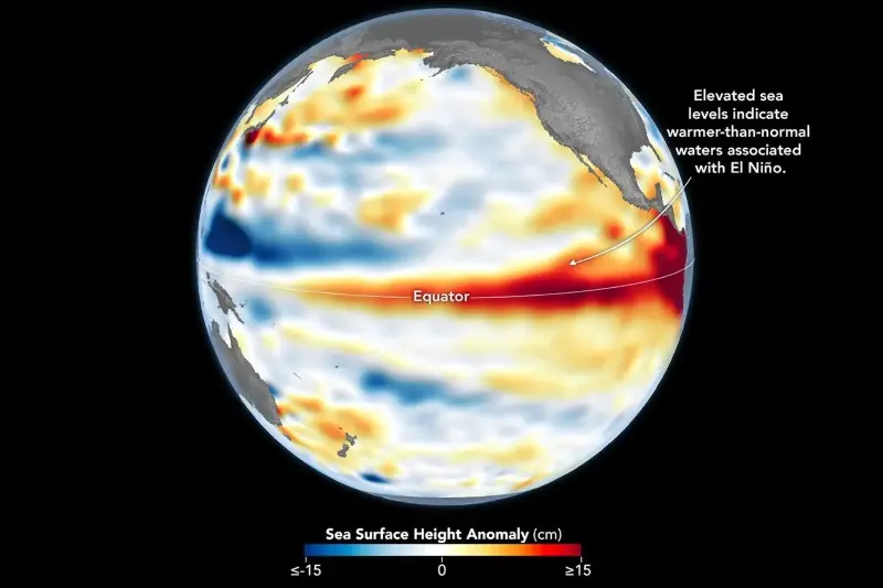
NASA satellite observations have detected higher-than-normal sea surface heights across parts of the central and eastern Pacific Ocean, offering another sign that El Niño has returned.
The finding comes from the Sentinel-6 Michael Freilich satellite, which observed sea surface height anomalies across the Pacific on June 8, days before the National Oceanic and Atmospheric Administration (NOAA) declared El Niño conditions on June 11.
NASA said areas shown in red on its map marked sea levels that were higher than average, while blue marked lower-than-average areas and white showed near-normal conditions.
The clue is tied to a simple physical process: warmer ocean water expands, raising the height of the sea surface. NASA said elevated sea surface height can therefore serve as an indicator of ocean temperatures, with warmer-than-normal waters and higher sea surface heights in parts of the equatorial Pacific associated with El Niño.
El Niño, which is marked by warmer-than-normal water temperatures in parts of the equatorial Pacific, returned in June 2026, with NASA saying observations from Sentinel-6 Michael Freilich indicated the event was continuing to strengthen that month.
Earlier in spring 2026, the satellite detected precursor signs of El Niño in the form of Kelvin waves—broad swells of warm water that moved from the western Pacific toward the eastern Pacific. NASA said these waves can form when trade winds in the western equatorial Pacific weaken and briefly reverse, allowing warm water to build in the east.
That buildup deepens the warm surface layer, lowers the thermocline—the boundary between warmer surface water and colder deeper water—and suppresses the upwelling that usually brings cooler water toward the surface along the Pacific coasts of the Americas. NASA said sea surface height observations capture that subsurface heat buildup and can show how much heat is stored below the surface, beyond what surface temperature measurements alone reveal.
NOAA’s Climate Prediction Center said in its June 11 ENSO Diagnostic Discussion that El Niño conditions were present and expected to strengthen into the Northern Hemisphere winter of 2026-27. The agency cited above-average sea surface temperatures across the central to eastern equatorial Pacific, along with wind, convection and other indicators that collectively reflected the onset of El Niño conditions.
NOAA also said there was a 63 percent chance of a “very strong” El Niño during November-January, which would rank among the largest El Niño events in the historical record going back to 1950. The agency cautioned that even very strong El Niño events do not produce expected impacts everywhere, although stronger events can tilt the odds more significantly toward typical outcomes.
What Is El Niño?
El Niño is the warm phase of the El Niño-Southern Oscillation, or ENSO, a natural climate pattern in the Pacific. NOAA describes ENSO as involving shifts between warm and cool waters in the central and eastern equatorial Pacific that alter where ocean heat is released into the atmosphere, influencing circulation, temperatures, precipitation and other weather events.
NOAA says El Niño occurs on average every two to seven years and typically lasts nine to 12 months. El Niño is the opposite of La Niña, the cool phase of ENSO, while neutral conditions fall between the two.
For El Niño conditions to form, NOAA says sea surface temperatures in the central and eastern tropical Pacific need to warm at least 0.5 degrees Celsius above normal and the atmosphere must respond, including through weakened trade winds and a shift in tropical rainfall patterns.
El Niño Impacts
El Niño can affect weather patterns around the world. NOAA says its largest U.S. impacts usually occur during Northern Hemisphere winter, when it typically brings milder weather to northern parts of the country and wetter conditions across the southern U.S.
NOAA also says ENSO can affect agriculture, wildfires and marine fisheries around the globe, adding that it can affect areas far from the tropical Pacific and can be linked to severe storms, mild weather, drought or flooding.